

3/28/25 – ANONYMOUS TIP LEADS TO MARINE PROTECTED AREA VIOLATIONS
|
JOSH GREEN, M.D. GOVERNOR |
DAWN CHANG |
ANONYMOUS TIP LEADS TO MARINE PROTECTED AREA VIOLATIONS
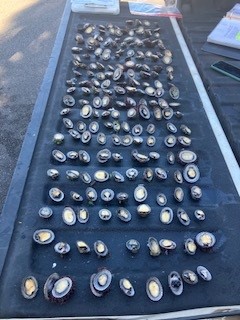
PŪPŪKEA, O‘ahu – An anonymous tip received by the DLNR Division of Conservation and Resources Enforcement (DOCARE) led to citations for two men allegedly engaging in prohibited activities within the Pūpūkea Marine Life Conservation District (MLCD), on O‘ahu’s North Shore.
On Wednesday, March 26, DOCARE officers were informed of two men seen picking ‘opihi at the southern end of the Pūpūkea MLCD. Officers responded and approached 53-year-old Elmer Ceredon of Wahiawā and 65-year-old Posadas Armando of ‘Ewa Beach.
Officers inspected their catch, which included 235 pieces of ‘opihi. While they were of legal size, taking any mollusk from the MLCD is prohibited and this includes seashells and ‘opihi.
Both men were cited for a violation of Rule 13-34-2 (1) of Hawai‘i Administrative Rules (HAR) relating to Prohibited Activities within the Pūpūkea MLCD. The pair is required to appear on petty misdemeanor charges in Wahiawā District Court on May 13.
DOCARE Chief Jason Redulla said “Activities in marine protected areas throughout the state, including the Pūpūkea MLCD, are highly restrictive to protect aquatic resources. These areas have signs posted informing people of these restrictions. We remind everyone to follow the rules and restrictions to avoid being cited or arrested.”
The Pūpūkea MLCD was established in 1983 as part of the state’s Marine Life Conservation District Program. MLCD’s carry the highest level of resource protection through regulations designed to protect marine life, allowing fish and other aquatic life to grow larger and produce more offspring, which can create a spillover effect to adjacent areas. The Pūpūkea MLCD boundary is established from the south end of Waimea Bay, northward past Sharks Cove.
# # #
RESOURCES
(All images/video courtesy: DLNR)
Photographs – Pupukea ʻOpihi violations, March 28, 2025: https://www.dropbox.com/scl/fo/cfwjahdy5zgq627rx6hop/AP4hQ3ESBYTQpKIoj_pHRoM?rlkey=a8mua8t635ozl2heeysw7igsr&st=5xuc42bb&dl=0
Media Contact:
Dan Dennison
Communications Director
Hawaiʻi Dept. of Land and Natural Resources
Email: Dlnr.comms@hawaii.gov
Distribution channels:
Legal Disclaimer:
EIN Presswire provides this news content "as is" without warranty of any kind. We do not accept any responsibility or liability for the accuracy, content, images, videos, licenses, completeness, legality, or reliability of the information contained in this article. If you have any complaints or copyright issues related to this article, kindly contact the author above.
Submit your press release